Crime Topic Data
In a national context, recorded crime in the Dorset Council area remains low compared to other police authority areas in England.
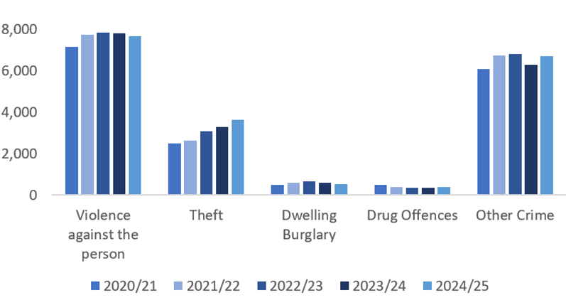
Total recorded crime has risen by 2% this year. However, reported anti-social behaviour incidents have decreased by 12% while the number of domestic abuse incidents has increased by 12%.
Data relates to the 2024/25 fiscal year unless stated otherwise
Download this report (PDF)Dorset Community Safety Partnership Priorities1
- Sexual Offences
- Domestic Abuse and Stalking
- Serious and Public Place Violence
- Anti-Social Behaviour
- Rural Crime
- In 2024-25 there were 4,771 incidents of anti-social behaviour in the Dorset Council area.
- 76% of these were classified as nuisance, 13% personal and 11% environmental.
- Weymouth has the highest rate of anti-social behaviour across the Dorset Council area.
- There were 773 serious sexual offences in the Dorset Council area last year.
- There were 4,328 domestic abuse incidents in the Dorset Council area last year.
Other Crime
- Total crimes were slightly higher this year than in the previous year.
- East Dorset is the area with the lowest crime rate in Dorset and Weymouth and Portland has the highest.
- Crime is highest in Dorset between May and October each year.
- In 2023 68% of residents surveyed across Dorset said that they felt safe in their local area after dark.
- In the past year, residential burglary accounted for 87% of acquisitive crimes, while robbery made up 13%.
- The highest number of robberies occurred in Weymouth & Portland, whereas the highest burglary rate per household was in West Dorset.
- Compared to other areas, crime in the Dorset Council area remains low.
Hate Crime4
- A hate crime or incident is any criminal offence or non-criminal incidence, perceived by the victim or any other person, as being motivated by prejudice or hate towards a person’s protected characteristic. There were 75 Hate crime and incidents in 2024/25 up from 27 last year - a 177% increase.
- The number of religious or racially aggravated crimes has risen in the last three years. There were 132 recorded cases in 2024/25, up from 85 in the last year - a 55% increase.
- A key focus of local policing on hate crimes is building trust and confidence in reporting, and ensuring that everyone knows how to report a hate crime or incident. Third-party reporting centres and trusted community partners play an important role in this.
- The council is a member of Prejudice Free Dorset, a partnership group made up of local agencies that seeks to promote inclusive communities and challenge prejudice across Dorset, so everyone can go about their daily lives safely and with confidence5.
Headline Figures
773
Serious sexual offences in Dorset last year
80%
Of sexual assaults are committed against women
4,771
Anti-social behaviour incidents
1 in 7
Of all anti-social behaviour incidents in Dorset occur in Melcombe Regis in Weymouth
4,328
Domestic abuse incidents
2%
Total crime up by
Headline Figures
773
Serious sexual offences in Dorset last year
80%
Of sexual assaults are committed against women
4,771
Anti-social behaviour incidents
1 in 7
Of all anti-social behaviour incidents in Dorset occur in Melcombe Regis in Weymouth
4,328
Domestic abuse incidents
2%
Total crime up by
Sources
- 1 Community Safety Partnership Performance Reporting, 2025
- 3 Compare your Area - Police UK
- 4 Dorset Police, 2024/25
- 5 Prejudice Free Dorset
16 Reports
Order by: Newest first
-
Research Bulletin - The Indices of Multiple Deprivation 2025
23 April 2026
Our latest Research bulletin looks at the latest release of the official measure of relative deprivation for small areas in England. It focuses on Dorset Council, what’s changed since the previous release and how the data can be used. The index is measured at a small area level (called Lower-layer Super Output Areas – LSOAs) in England with an average of 1,500 residents in each. In a national context, Dorset as a whole does not score highly in relation to deprivation. However, we still have pockets of deprivation. Read the report to get the overall picture for Dorset.
Downloads: 117
-
The Indices of Deprivation 2025 - a summary report for Dorset Council
23 April 2026
The English Indices of Deprivation helps identify and prioritise areas to assist the government and other agencies (both nationally and locally) in narrowing the gap between deprived neighbourhoods and the rest of the country.
Downloads: 150
-
State of Dorset 2025 - Crime
27 January 2026
This is the key annual document bringing together the "picture" of Dorset based on the statistical evidence. This is just the Crime topic
Downloads: 184
-
Tagged:
- Crime
-
State of Dorset 2025
27 January 2026
This is the key annual document bringing together the "picture" of Dorset based on the statistical evidence.
Downloads: 309
-
State of Dorset 2024 - Crime
28 January 2025
This is the key annual document bringing together the "picture" of Dorset based on the statistical evidence. This is just the Crime topic
Downloads: 654
-
Tagged:
- Crime
-
State of Dorset 2024
28 January 2025
This is the key annual document bringing together the "picture" of Dorset based on the statistical evidence.
Downloads: 1485
-
State of Dorset 2023 - Crime
01 January 2023
This is the key annual document bringing together the "picture" of Dorset based on the statistical evidence. This report contains just the Crime topic.
Downloads: 781
-
Tagged:
- Crime
-
State of Dorset 2023
01 January 2023
This is the key annual document bringing together the "picture" of Dorset based on the statistical evidence. It covers eleven key areas: Economy, Deprivation, Older People, Children, Health and Care, Natural and Historic Environment, Leisure and Culture, Crime, Diversity, Population and Housing
Downloads: 1309
-
State of Dorset 2021 – Crime
06 July 2022
This is the key annual document bringing together the "picture" of Dorset based on the statistical evidence. This report contains the Crime topic and covers the Dorset Council area.
Downloads: 1263
-
Tagged:
- Crime
-
State of Dorset 2021
06 July 2022
This is the key annual document bringing together the "picture" of Dorset based on the statistical evidence. It covers 10 key areas: Population, Children, Crime, Deprivation, Diversity, Economy, Health and Care, Leisure and Culture, Natural and Historic Environment, and Older People, covering the Dorset Council area.
Downloads: 1917
-
The Indices of Deprivation 2019 - a summary report for Dorset Council
28 November 2019
The English Indices of Deprivation helps identify and prioritise areas to assist the government and other agencies (both nationally and locally) in narrowing the gap between deprived neighbourhoods and the rest of the country.
Downloads: 6593
-
Our Communities Bulletin -The Indices of Multiple Deprivation 2019
07 October 2019
Our latest Our Communities bitesize bulletin looks at the latest release of the official measure of relative deprivation for small areas in England. It focuses on Dorset Council, what’s changed since the last release in 2015 and how the data can be used. The index is measured at a small area level (called Lower-layer Super Output Areas – LSOAs) in England with an average of 1,500 residents in each. In a national context, Dorset as a whole does not score highly in relation to deprivation. However, we still have pockets of deprivation. Read the report to get the overall picture for Dorset.
Downloads: 2231
-
Our Communities Topic Report - Dorset's Coastal Communities
06 October 2017
According to a report written by the Social Market Foundation, on average, coastal communities are less productive economically than non-coastal communities. They often have lower levels of pay, higher rates of unemployment and have populations with lower skill levels and poorer health. Four of Dorset's district councils are coastal communities, along with Bournemouth and Poole. The socioeconomic picture across Dorset's coastal communities varies considerably. This bulletin looks at why this matters for Dorset.
Downloads: 2476
-
Our Communities Topic Report - Anxiety Bulletin
23 August 2017
Surveys have shown that feelings of anxiety and well-being can change considerably through a person's life. This bulletin looks at anxiety levels across Dorset, including how certain factors can affect levels of anxiety and other measures of well-being.
Downloads: 2221
-
Preparing for the 2021 Census - Testing the next Census in West Dorset, 2017
15 March 2017
The Office for National Statistics (ONS) will be carrying out a census test in West Dorset this year. This is an important part of their preparations for the 2021 Census. The attached document explains in more detail, or go to www.dorsetforyou.com/census-test-2017 for more information.
Downloads: 1988
-
Our Communities Topic Report - Crime Bulletin
05 October 2016
This edition will include a local perspective on a national issue using data to build a picture of crime across the County and identify priority areas. Last year there were 2,321 domestic abuse incidents in Dorset and 9,071 anti-social behavioural incidents across Dorset in 2015/16.
Downloads: 1749
-
Tagged:
- Deprivation
- Population
- Crime
14 Related Datasets
Order by: Newest first
-
Indices of Deprivation 2025 - Dorset Council
Published: 23 April 2026
This pdf illustrates national deprivation levels Dorset Council. There are range of maps which look at a range of components of deprivation including health, income, employment, education and skills, living environment, crime and barriers to housing and services. There is also a multiple deprivation map that combines all these aspects of deprivation to give us an overall picture. The document also has a number of maps that look at specific aspects (sub domains) such as deprivation affecting children and outdoor living environment.
Downloads: 64
-
Indices of Deprivation 2025- National and Dorset Council Ranks
Published: 23 April 2026
The English Indices of Deprivation helps identify and prioritise areas to assist the government and other agencies both national and local in narrowing the gap between deprived neighbourhoods and the rest of the country.
Downloads: 64
-
Indices of Deprivation 2019- National and Dorset Council Ranks
Published: 03 January 2020
The English Indices of Deprivation helps identify and prioritise areas to assist the government and other agencies both national and local in narrowing the gap between deprived neighbourhoods and the rest of the country.
Downloads: 2809
-
Indices of Deprivation 2019 - Dorset East Sub Unitary Geography (SUG) Maps
Published: 11 December 2019
This pdf illustrates national deprivation levels at a small geography across Dorset East SUG area for 2019. There are sixteen maps which look at a range of components of deprivation including health, income, employment, education and skills, living environment, crime and barriers to housing and services. There is also a multiple deprivation map that combines all these aspects of deprivation to give us an overall picture. The document also has a number of maps that look at specific aspects (sub domains) such as deprivation affecting children and outdoor living environment.
Downloads: 1771
-
Indices of Deprivation 2019 - Dorset West Sub Unitary Geography (SUG) Maps
Published: 11 December 2019
This pdf illustrates national deprivation levels at a small geography across Dorset West SUG area for 2019. There are sixteen maps which look at a range of components of deprivation including health, income, employment, education and skills, living environment, crime and barriers to housing and services. There is also a multiple deprivation map that combines all these aspects of deprivation to give us an overall picture. The document also has a number of maps that look at specific aspects (sub domains) such as deprivation affecting children and outdoor living environment.
Downloads: 2327
-
Indices of Deprivation 2019 - Mid Dorset Sub Unitary Geography (SUG) Maps
Published: 11 December 2019
This pdf illustrates national deprivation levels at a small geography across Mid Dorset SUG area for 2019. There are sixteen maps which look at a range of components of deprivation including health, income, employment, education and skills, living environment, crime and barriers to housing and services. There is also a multiple deprivation map that combines all these aspects of deprivation to give us an overall picture. The document also has a number of maps that look at specific aspects (sub domains) such as deprivation affecting children and outdoor living environment.
Downloads: 1925
-
Indices of Deprivation 2019 - South East Dorset Sub Unitary Geography (SUG) Maps
Published: 11 December 2019
This pdf illustrates national deprivation levels at a small geography across South East Dorset SUG area for 2019. There are sixteen maps which look at a range of components of deprivation including health, income, employment, education and skills, living environment, crime and barriers to housing and services. There is also a multiple deprivation map that combines all these aspects of deprivation to give us an overall picture. The document also has a number of maps that look at specific aspects (sub domains) such as deprivation affecting children and outdoor living environment.
Downloads: 2353
-
Indices of Deprivation 2019 - Dorset North Sub Unitary Geography (SUG) Maps
Published: 11 December 2019
This pdf illustrates national deprivation levels at a small geography across Dorset North SUG area for 2019. There are sixteen maps which look at a range of components of deprivation including health, income, employment, education and skills, living environment, crime and barriers to housing and services. There is also a multiple deprivation map that combines all these aspects of deprivation to give us an overall picture. The document also has a number of maps that look at specific aspects (sub domains) such as deprivation affecting children and outdoor living environment.
Downloads: 2100
-
Indices of Deprivation 2019 - Dorset South Sub Unitary Geography (SUG) Maps
Published: 11 December 2019
This pdf illustrates national deprivation levels at a small geography across Dorset South SUG area for 2019. There are sixteen maps which look at a range of components of deprivation including health, income, employment, education and skills, living environment, crime and barriers to housing and services. There is also a multiple deprivation map that combines all these aspects of deprivation to give us an overall picture. The document also has a number of maps that look at specific aspects (sub domains) such as deprivation affecting children and outdoor living environment.
Downloads: 1651
-
Indices of Deprivation 2019 - Dorset Council Maps
Published: 25 November 2019
The combined map base pdf illustrates national deprivation levels at a small geography across Dorset for 2019. There are sixteen maps which look at a range of components of deprivation including health, income, employment, education and skills, living environment, crime and barriers to housing and services. There is also a multiple deprivation (IMD) map that combines all these aspects of deprivation to give us an overall picture for Dorset. The document also has a number of maps that look at specific aspects (sub domains) such as deprivation affecting children and outdoor living environment.
Downloads: 1367
-
Crime and Anti-social Behaviour types by district 2011-2016
Published: 12 December 2016
Summary crime data at Local Authority level.
Downloads: 1523
-
Tagged:
- Crime
-
Crime Data by Main Crime Groups - 2015/2016, Dorset Local Authorities
Published: 08 December 2016
2015/2016 crime numbers and crime per 1,000 population by Main Crime Groups (by district).
Downloads: 1703
-
Tagged:
- Crime
-
Domestic Abuse Statistics - Data Tool
Published: 08 December 2016
An overview of available statistics and data relating to domestic abuse, for individual Police Force Areas (plus regional and national figures). Raw data available for independent analysis.
Downloads: 2242
-
Tagged:
- Crime
-
English Indices of Deprivation 2015
Published: 30 September 2015
This English Indices of Deprivation helps identify and prioritise areas to assist the government and other agencies both national and local in narrowing the gap between deprived neighbourhoods and the rest of the country.
Downloads: 2930
-
Tagged:
- Economy
- Deprivation
- Crime
1 Related Dashboards
-
Indices of Deprivation 2019
This dashboard uses data published by Central Government to measure deprivation in many different facets at a small geography across Dorset.